Helsinki’s New Jokeri LRT Opens Early And $19 Million Under Budget
Europe’s newest light rail line just opened and our local tax hungry politicians and bureaucrats should take note!
Broadway subway – $2.7 billion for 5.7 km. (not including vehicles, electrical/signalling upgrades)
Proposed Expo line Extension to Langley – Almost $5 billion for 16 km. (not including vehicles, electrical/signalling upgrades)
Helsinki’s Jokeri Line, including vehicles – $819 million for 25 km!
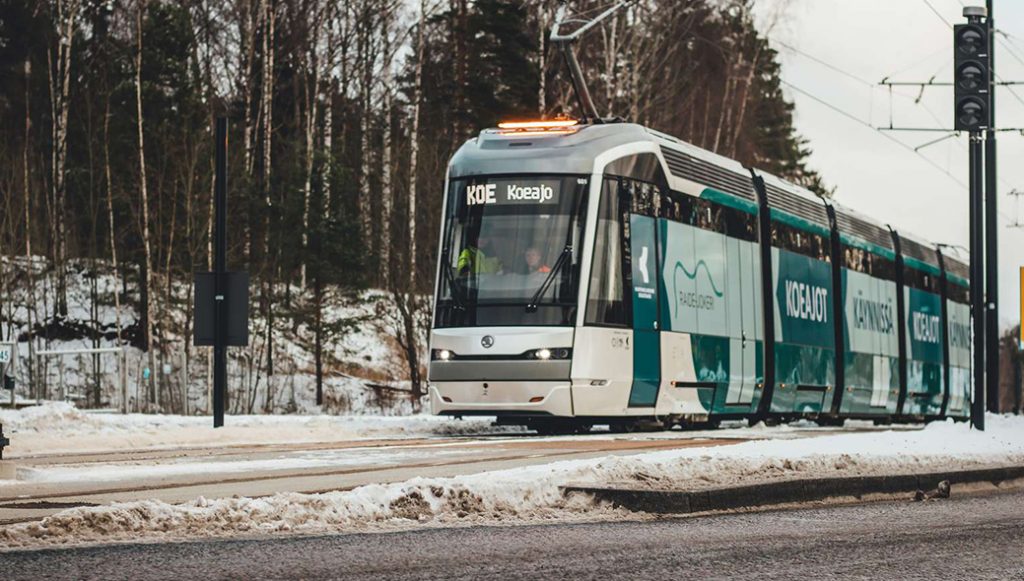
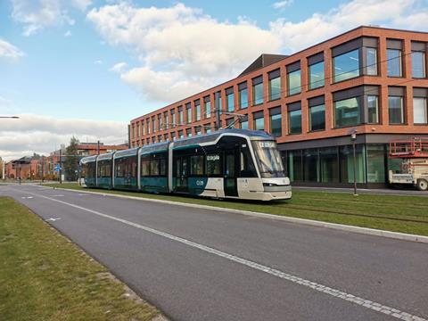
The Jokeri LRT ot Helsinki’s route 15, is a 25-kilometre (16 mi), 34 station light rail line connecting Keilaniemi in Espoo and Itäkeskus in Helsinki, Finland. The line started operating in October 2023, about 10 months ahead of the original schedule. The line will eventually replace trunk bus line 550, the busiest bus service on the Helsinki Regional Transport Authority public transport network.
The 25 km line cost €562 million or CAD $819 million and came in €13 million or CAD $19 million under budget and opened ten months early!
As Translink pleads poverty to any and all who would listen, a comment from American Transportation Engineer who worked on many pioneering US light rail projects, in 2008, when he shredded the Evergreen lines business case.
But, eventually, Vancouver will need to adopt lower-cost LRT in its lesser corridors, or else limit the extent of its rail system. And that seems to make some TransLink people very nervous.
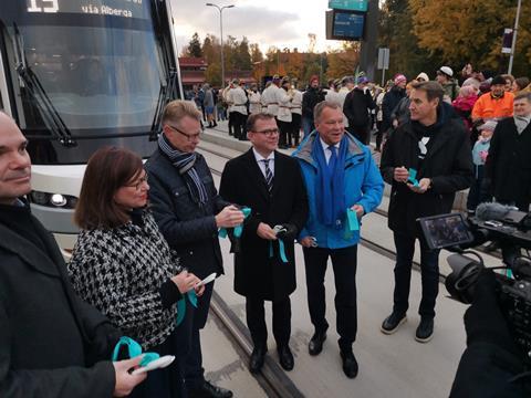
Jokeri light rail line opens early and below budget
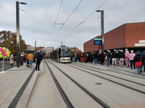
FINLAND: Helsinki Regional Transport opened its 25 km orbital light rail line serving the Helsinki-Espoo conurbation for revenue service on October 21, almost a year ahead of schedule.
Running from Itäkeskus in eastern Helsinki to Keilaniemi in neighbouring Espoo to the west, the line is branded Jokeri as an abbreviation of JOukkolikkenteen KEhämäinen Raide Investointi (mass transport ring rail investment).
It runs in an arc around the capital, which is located on a pear-shaped peninsular connected by three radial highways. Around 16 km of the route is located in Helsinki and 9 km in Espoo.
Being promoted as an ‘express tram’, the Jokeri LRT is intended to replace bus Route 550, which since being launched in August 2003 has become HSL’s busiest with 40 000 passengers/day on weekdays. The end-to-end journey time of 65 min, an average speed of 25 km/h, is similar to the bus timetable, but the trams will not be subject to delay by traffic jams. The bus service is expected to cease running at the end of the year.
Planning and construction
The light rail line was first mooted around 1990, but it was not until June 2008 that the city of Helsinki commissioned a detailed plan, which was presented in May 2009.
The scheme was finally approved in 2016, and construction began in June 2019.
Tracklaying was completed in August 2022, and test running finished in September. The route was originally expected to open in summer 2024, but the target date was brought forward to January and then to October 2023.
The line has been developed by the Jokeri Rail Alliance, set up by the two cities to bring the promoters, designers and contractors into a single umbrella organisation. The double-track line has been built to 1 000 mm gauge for compatibility with HKL’s legacy tram network. It serves 34 stops at an average spacing of approximately 800 m. Three of these provide interchange to the metro stations at Itäkeskus, Aalto University and Keilaniemi and three to suburban railway stations at Oulunkylä, Huopalahti and Leppävaara. Construction of the line required four new bridges over the radial highways and one of the city’s ring roads, plus a 300 m tunnel at Patterinmäki.
Civil works were budgeted at €382m with another €108m for the rolling stock plus €70m for the dedicated depot at Roihupelto bringing the total to €562m.
The cost of the project has been split three ways. The national government contributed €84m, and the remainder has been divided between the municipal administrations in Helsinki (65%) and Espoo (35%). According to HSL, the line has been completed around €13m below budget.
Vehicles and services
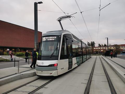
The line will be operated by a fleet of 29 ForCity Smart Artic X54 supplied by Škoda Transtech. These are a longer version of the Smart Artic cars previously supplied to HKL and similar to those in operation in Tampere.
The five-section low-floor cars are 34 m long, with provision to incorporate an extra 10 m section if demand increases in the future. Each car can carry up to 214 passengers, including 78 seats and four spaces for wheelchairs or prams, and can run at speeds up to 70 km/h. The trams are finished in a white and petrol blue livery which like the interior was developed by Finland’s Idis Design.
Tram services operate from 04.30 to 01.15 each weekday, starting an hour later at weekends. As only 15 trams have so far been delivered the initial headway is 10 to 12 min, but the frequency will increase to a tram every 6 min when all 29 are available, allowing the bus route to be withdrawn. Zonal fares are charged, with a flat fare of €2·80 for travel in either Helsinki or Espoo and €3·10 for both zones, all valid for 80 min.
Environmental improvements include an estimated reduction of around 85% in CO2 emissions and 95% in NOx emissions compared to the 550 bus. The trams are expected to carry more than twice as many passengers, reaching an estimated 91 000 passengers/day by 2030. Total ridership is projected at 3·5 million trips for the remainder of 2023 and up to 15 million in 2024. The line is also expected to encourage commercial and residential development in both Helsinki and Espoo.
Plans are being developed for extension of the line to serve Viikki, Pasila, Otaniemi and Tapiola. This would follow the completion of HKL’s 5·5 km Crown Bridges light rail line linking Helsinki with its fast-growing eastern suburb of Laajasalo, which is scheduled to open in 2027.


I want to focus our attention on the length of the Jokeri line: 25 km/34 stations [built for $32.8 million per km, including trains].
The way to end the Housing Affordability Crisis in our regions is to build guaranteed affordable houses in perpetuity—or CMHC GAHP—as neighborhood infill and new tramtowns, along modern tram lines or Streetcar|LRT.
The only way to guarantee affordable houses—according to CMHC—is by writing a contract on title limiting the resale price of the property in perpetuity.
Think of it a Co-op housing building in a variety of different forms: as single houses, row and courtyard houses. All with their own address, and a front door opening directly on the street or courtyard. All limited in resale value to, say, purchase price + CPI adjustment for inflation.
So why post this on a transit website?
Up until now, transit in Greater Vancouver has been built on the Skytrain-and-Towers paradigm. Yet, the Skytrain footprint of service covers just 100 sq. mi.—or 14% of the region.
After almost forty years of building, the Skytrain has managed to provide about the same reach of service as 3 Jokeri lines, but half as many stations. The total length of the system is 80 km, with just 53 stops. Twenty-two of those stations are on the Skytrain Loop, which by definition, does not extend the reach of transit.
Rather than build a hub-and-spoke system, Skytrain technology operates an inner loop inside the region’s urban core. That works for moving smaller amounts of people for short distances.
However, the ALRT technology is not suitable for operating commuter or regional service. There is no explaining away this fact by Translink—no spin will change that reality.
The result? The Skytrain is the main driver behind the Housing Affordability Crisis now plaguing our regions.
By building a Skytrain Loop we have constrained access to land where it is most abundant and cheap: on the regional periphery and neighboring regions.
Economists will tell us that constraining access to land triggers crises in housing affordability. End of story.
As folks here don’t tire of explaining to me, by adding a café car for convenience (WCs and food bar), the Jokeri line would be able to operate commuter services as far as 200 km away. With station spacing becoming greater as the tramtrain moves away from the core, perhaps something like a total of 65 stops might build on the periphery. That makes for a 200 km line with a total of 100 stations, urban and regional.
All manner of savings in building the line enter into the picture as we expand service service into the periphery. Things that I am really not qualified to outline. However, a 200 km trip would be completed in 2.5 hours by express trains stopping at select stations, averaging 80 km per hour. Commuters would ride in comfort, with free wifi, free electrical charging and café service.
What I am qualified to describe is what can be achieved as GAHP in 35 urban stops, and 65 new exurban tramtowns.
First, consider that the catchment of the urban stop is a 15 minute walking distance—defining an area equal to 1,133 acres. That is not an unreasonable distance to walk for good commuter service.
Inside each urban station catchment we can house 10,000 souls, in human-scale GAHP units, at an infill rate of just 4 units per acre. Which means the urban stops have a threshold potential of housing 35 x 10,000, or 350,000 people. Clearly, many will achieve intensification well over these numbers, while still building products less than four storeys in height.
For illustration purposes, 2.5 storey houses on 33-foot lots have a density of 15 units per acre; 21 u/a with a carriage house added. 3.5 storey row houses have a density of 42 u/a. And courtyard houses less than 4 storeys in height have densities ranging from 40 to 120 u/a. We will use an average of 80 u/a for courtyard houses and apartment buildings.
On the urban periphery, new tramtowns can be limited in size to 120 acres, or a radius equal to a 5 minute walking distance, in order to prevent sprawl.
Half of the town footprint can accommodate 4,500 residents in single house lots. One quarter can accommodate 3,000 residents in 3.5 storey row houses. The remaining quarter can house 2,500 in 3.75 storey courtyard houses, plus three or four 6-storey apartment buildings. 10,000 people living on 120 acres, or 80 to 85 people per acre is human scale density. Thus, a total population of 10,000 can live in GAHP houses, row houses, courtyard houses and four apartment buildings with retail on the ground floor, a 5 minute walking distance from regional tram train service, in new tramtowns.
In all we can house 350,000 in infill houses at 35 urban stops; and 650,000 in new tramtowns on the urban periphery; for a total population of 1 million per commuter rail line. All housing can be guaranteed affordable in perpetuity provided we are building on government owned land.
This is not rocket science.
For example, it’s what was done at South False Creek in the 1970s. Build out would take place over ten years. Although it might be necessary to accelerate build out to coincide with the completion of the rail line, ending the housing crisis by 2030.
Let’s see how this will melt away the Translink deficit.
What we have demonstrated on the back of an envelope, using the Jokeri line as a starting point, is that we can house 1 million souls per 200 km Streetcar|LRT line, on houses built guaranteed affordable forever.
On this website, I take it that a Granville Island-Chilliwack service, using the 30% wheelage reserved on the NW Rail Bridge, is a slam dunk.
[Jokeri cost, including trains: 125 km x $32.76 million/km = $4.1 billion]
A second line might operate between YVR-Whistler. Most of the readers here will be aware that the Canada Line tunnel, and Waterfront Station, were not built deep enough to serve a tunnel crossing the Burrard Inlet. Thus, using the Canada Line before entering its own tunnel linking Granville Island and Lonsdale, the service would then travel 120 km to Whistler.
[Jokeri cost, including trains: 120 km x $32.76 million/km = $3.9 billion].
The question I have is whether the service may not begin operations by renting CPR ROW—how would that affect costs? We know from Trillium in Ontario, and the WCE here, that headways would be affected to a minimum of 12 minutes.
I have a great deal of confidence that a Snow Line to Whistler would win us a second Winter Olympics. A great deal of the attraction would be building Olympic Villages west of Cambie Bridge on South False Creek; at Whistler; perhaps Pemberton; and in the interior as GAHP. A Winter Olympics with a theme of guaranteed affordable housing in perpetuity, in neighborhoods and villages, hardwired to the airport and the regional job core by Streetcar|LRT, sounds like a sure bet to get the nod from the selection committee.
Finally, to round out the regional network linking together the neighborhing regions of Whistler-Lillooet, Vancouver and the Fraser Valley, we can think of a 165 km service from Horse Shoe Bay to Hope, crossing a renamed ‘Indian Arm’ and travelling North of Fraser along Lougheed Highway, Dewdney Trunk, and other alignments.
[Jokeri cost, including trains: 165 km x $32.76 million/km = $5.4 billion]
I never cease to be impressed by the Portland Max and Streetcar. Owing to street R.O.W.s measuring 50-feet inside the historic, square mile Portland plat, only one track is laid down per street. I wonder what good transportation practice returns here: In places North of Fraser, where Dwedney Trunk parallels the Lougheed Highway at a distance of 1,320 feet, westbound service could ride one corridor, and eastbound trains on the other.
In any case, the three lines combined, support 3 million Canadians living in GAHP neighborhoods and new tramtowns. All hardwired to the regional job core, the airport, etc., by modern Streetcar|LRT.
Jokeri cost for the three lines would total $13.4 billion.
A tad over the $11 billion Zwei is reporting to extend the Expo and Millennium lines. However, in this case, we would be delivering a total 409 km of service. 5-times what Skytrain achieved in its first 40 years.