Before reading on, please remember this figure of $1.3 billion, as it represents an updated (2021) cost for Rail for the Valley’s Leewood Study, offering a three trains per hour per direction from Vancouver to Chilliwack.
Doing the Rail for the Valley blog for the past 12 years has been an interesting experience and I have learned a tremendous amount. To keep the RftV blog credible, I had to reach out to real professionals to get an accurate account of our transit situation in Metro Vancouver. Their comments are gob-smacking!
The following is from RftV’s old friend, a transportation engineer from Ottawa, who uses the avatar Haveacow.
Mr. Cow wishes to remain anonymous due to the small and arcane world of transit planning in Canada, which for telling the truth, could mean being blackballed or worse.
This from another engineer commenting why Mr. Cow uses an avatar.
…… can understand the reason for the pseudonym I know they once found out what they thought was mine (it was) and I paid dearly for it.
The SkyTrain lobby just love to get even with those who deal in fact.
The main takeaways are from this fact filled essay on the future of the Expo Line reaching Langley:
The Expo line extension is no longer a TransLink project, it is a provincial project being driven by the premier’s office.
Surrey Mayor McCallum’s claim that the Expo Line extension to Langley would cost $1.63 billion was wildly wrong, yet no one, except Rail for the Valley, said anything! Where was the Mayor’s Council on Transit; where was the ministry of Transportation; where was TransLink’s CEO; who was protecting the taxpayer?
There is currently no funding agreement, no business plan, no direction at all.
The cost of the completion of the Broadway subway will cost $4.98 to $5.12 Billion and will take precedence over the Expo Line extension to Langley.
Structural concrete prices increases alone, could add anywhere from $36 Million to $55 million per year on top of just the basic inflation for both projects.
No mention of the much needed $3 billion rehab.
TransLink has serious financial issues.
Dismal reading, as premier Horgan seems to be following the path of former premier Glen Clark and his liking of FastFerry boondoggles. We all know what happened afterwards, the NDP were unelectable for 19 years.
Premier Horgan is playing with fiscal fire a la the dread FastFerry fiasco!
It is extremely scary for both the taxpayer and the transit customer that the premier’s office is driving the expansion of SkyTrain, especially to Langley because we all know, when the premier of the province gets involve, common sense fiscal responsibility are thrown out the window, as the projects becomes a personal ego trip and we all know, premiers cannot seem to be wrong, especially at election time.
First, let us be honest with ourselves folks. I have crunched some numbers. The change in scope for the Surrey to Langley Skytrain Expo Line Extension Project (The SLS), from 2 stages into a single stage project was because of cost and nothing else. The cost to go 7 km to Fleetwood was around $1.69 Billion to $1.72 Billion, exceeding the $1.63 Billion budget. This is why they combined the 2 stages into a single stage project. The project to Fleetwood died months ago.
According to the second stage of Translink’s 10 year funding plan and the Rapid Transit Funding Agreement for the Surrey LRT Line, roughly $165 Million of that $1.63 Billion was coming from some past but mostly future tax and fee revenues (2018-2028 period). Translink’s local fuel taxes, development charges, parking fees, property tax increases as well as targeted amounts of Translink’s own passenger revenues were to help fund roughly 8.6% of the $7.3 Billion Second Stage of the 10 year funding plan, roughly $627.8 Million in total. This plan included the Broadway Millennium Line Extension to Arbutus, the Surrey LRT Line and many, many other smaller capital programs.
So far, the Translink funding for the Broadway extension is unaffected (no surprise). However, because of the pandemic, Translink is short $78.8 Million in planned revenues from 2019 and 2020 (their figures not mine), 2021 is not done yet and it may take years for Translink revenues to return to pre-pandemic levels. So it’s not $1.63 Billion in existing rapid transit funding, it’s actually around $1.55 Billion and dropping. If you don’t want to touch rapid transit funding, no less than $78.8 million must be taken out of the remaining $2.88 Billion in capital funding for the many other projects of the second stage of Translink’s 10 year capital funding plan.
My point, turning the Surrey to Langley Skytrain extension plan from a 2 stage plan to single stage plan was no gift to the public, the finances around the original 2 stage funding plan for the extension, quietly died. The massive increase in construction costs and the loss of Translink revenue from the pandemic, killed it.
Not only is a new business case needed but a whole new funding plan as well and it’s going to take 2 to 3 years to redo this process. So let’s be honest, currently, there isn’t enough funding for this $3.95 Billion extension. No business case, no funding plan, Translink isn’t even involved in the project management anymore, this is now a completely provincially run project. Translink may not be capable of being a full financial partner in this project or any other large capital project for some time, due to its current budget issues.
You have a PROMISE of $1.3 Billion but no specific formal funding agreement from the federal government as of yet (you guys are so lucky the Conservatives didn’t get elected).
The province of BC is now completely running the Surrey to Langley Extension. The project is $3.95 Billion and they could be having to kick in the entire remaining, $2.65 Billion, assuming there are no other cost increases in the coming months and the Liberals make good on their pre-election funding promise. This is not a good thing for the Surrey Extension.
The dark cloud on the horizon is beginning to show itself. According to the last information I had, Translink had to begin serious final planning and engineering on the second stage of the Broadway Millennium Line extension from Arbutus to UBC by 2024, if construction was to begin in 2026.
Again I crunched the numbers, as of today (in 2021 dollars), I estimate this extension project to cost between $4.98 to $5.12 Billion for the planned 7.3 km long tunnel and above grade structure into UBC, that’s right now, 2021. Zwei, can tell you about my accuracy in these matters if you don’t believe me. The actual date of final bidding and procurement will determine its actual final cost, when that is complete the final total will be known.
Again, I predict the cost of the Broadway Millennium Line extension from Arbutus to UBC to be between $4.98 and $5.12 Billion and the cost is growing between $158 to $164 Million every year due to the current estimate of inflation. That cost figure range I just gave you doesn’t include inflationary costs of construction materials, which is usually considerably higher than the basic inflation rate. Structural concrete prices increases alone, could add anywhere from $36 Million to $55 Million per year on top of just the basic inflation.
With the BC Ministry of Transportation and Infrastructure in control and probably having to kick in most if not all of the remaining $2.65 Billion for the Skytrain to Langley as well as the coming political pressure to fund the UBC extension, assuming they again have to pick up almost 2/3 of that project in 2024, (to finish it around 2031), this leaves a total cost for the UBC project in 2024, to be around $5.62 Billion. Which means, a roughly 2/3 funding portion of $3.77 Billion for the BC government.
In a fight for just British Columbia’s portion of 2 Skytrain line extensions, whether they pay $2.65 Billion for the Langley project or wait and fund $3.77 Billion for UBC extension, both will not be funded at the same time. I believe Langley will lose out in this choice. Unless something drastically changes soon, the current Langley Skytrain extension project in its present form is dying and may be put off, well into the next decade.
Even when experts told people during your last civic election he was dead wrong, Surrey’sMayor’s claim of $1.63 billion was wildly wrong. The current Mayor said he could build this entire Skytrain project to Langley for just $1.63 Billion! Fun times! I warned everybody then, kill the LRT line, you are going to get nothing until the 2030’s.
And to think, we could have had Rail for the Valley’s Vancouver to Chilliwack passenger rail service, with a maximum of three trains per hour per direction, connecting Vancouver and Chillwack to Sadrdis/Vedder, Abbotsford, Langley, Cloverdale, and North Delta/Surrey for $1.3 billion!
So the opening of the Expo Line extension to Langley has been delayed to 2028, well don’t bet the farm on it as a more realistic date is 2030, if ever!
One just has to laugh at the politicians and bureaucrats circling the wagons defending the Expo Line extension to Langley. The truth has seemed to take a holiday with the various comments.
Cut through the politcal blather and the reality is that this 16 km, now over $4 billion light metro projects will probably not take a car off the road.
Remember the nonsense touted by politicians with the Canada line that over 200,000 car journey’s will be taken off the road?
Well, it never happened and all we get is typical TransLink spin. The limited capacity Canada Line, has not shown any modal shift from car to transit. I can also say from personal experience, that driving to Richmond to collect family members after 8 PM,when buses only ran hourly, became a two to three time weekly event, pre Covid!
In 2017, mode share for transit in the metro Vancouver region was dropping from about 14% to 12%.
This is hardly indicative of a successful public transit system.
The many problems associated with the Expo Line extension to Langley has been discussed before including, wrong technology, obsolete technology, huge cost (now past $4 billion), lack of operational flexibility, change of commuter driving habits, the Serpentine Valley, possible abandonment of production of the Movia Automatic Light Metro now owned by by Alstom, the escalating $1 billion shortfall in funding and more.
The true believers will still shout their support for SkyTrain, but ignore the real issues such has funding the $1 billion funding shortfall and the never mentioned but most needed $3 billion rehab of the Expo and Millennium Lines.
As TransLink is still held in high odor by the taxpayer, increasing taxes to fund an obsolete light metro system, on a route it is ill suited for, will make for an interesting civic election in 2022!
The SkyTrain wall of transit, coming to Langley, well maybe!
Surrey-to-Langley SkyTrain won’t be up and running until 2028
The Surrey-to-Langley SkyTrain won’t be up and running until 2028, says a new report that will be presented to TransLink’s board of directors this week.
“Opening day” for the much-anticipated, 16-kilometre line has been delayed three years from the projected completion date of 2025, according to the update that will go before the board on Sept. 23.
The report says federal funding for the project, which permits an expansion of the project’s initial scope, “introduces additional requirements.”
In July, the federal government committed up to $1.3 billion in additional funds for the project, allowing it to extend from six stops to eight, beginning at King George Station in Surrey City Centre and ending at Langley Centre.
On Tuesday, Surrey Mayor Doug McCallum sent a statement express frustration with the delays, calling them “disconcerting.”
“It has been close to 30 years since the last rapid transit expansion in Surrey,” he said.
“For a city that is home to close to 600,000 people, rapid transit is long overdue and is of critical need now.
When completed, the Surrey-Langley SkyTrain is expected to increase the size of the Expo and Millennium Line network by 24 per cent, bringing the total track length from 66 to 82 kilometres.
Langley Mayor Val van den Broek has also said the project could bring “more than 25,000,000 active transportation trips” by the date of its completion.
In his statement, McCallum lamented that the jobs the project would create will also be punted further into the future.
“The time of talk and promises must come to an end,” he wrote.
“What we need now is the political will by all levels of government to get this long talked about project off the drawing board and to get shovels into the ground.”
Some additional funding must still be identified in order to pay the $3.94-billion tab for the line, and the report lists other action items, including clarifying TransLink’s responsibilities for the project.
An investment plan must also be developed, the report says, to account for the line’s finances, ridership and other outcomes.
In the first week of July’s record heat and the fireball that turned the Village of Lytton, which for the previous three days recorded the highest temperatures in Canada, to ash, our politicians stood mute. Oh, there were those 10 second sound bites and photo-ops of care, but the lesson did not sink in.
It seemed not one politician seemed to grasp the real meaning of Global Warming and continued to treat the subject as a talking point in photo-ops, but nothing more.
Federally, $10 a day daycare is more important to politicians and the media than BC changing climate and how to deal with it.
The provincial government seems utterly inept in handling the Global Warming crisis, with the premier actually going on a holiday in the middle of this summer’s wildfire crisis. If the NDP are inept at handling this major emergency, how can they tackle the massive global warming issue?
What is the government doing to mitigate global warming?
Not much!
Government increased the carbon tax and other user fees, but that is a bureaucratic/photo-op solution that taxes the poor but in reality does nothing. The bureaucratic/photo-op solution tries to portray that to fight global warming, the taxpayer must feel pain.
No pain, no gain!
It also gives the government more money to had out to politcal friends and insiders.
Oh, the federal, provincial, and regional governments are funding a $4.8 km extensions to the Expo and Millennium light-metro lines, but again, great for photo-ops at election time, but as a solution, not even close.
Even though over $15 billion of the taxpayer’s monies have been invested on light metro in Metro Vancouver, pre Covid, mode share for transit is dropping!
Yet, the government continues to do the same things over again, hoping for different results.
Global warming is a fact, yet government will not take the real steps needed to help mitigate the many issues associated with a warming earth. The government spends billions of dollars building bigger tunnels and bridges for cars and trucks, yet ignores any sort of rail alternative for carrying freight and passengers. The government spends billions of dollars on prestige rapid transit projects, not ignores cheaper and more viable rail solutions.
Better politically to invest $4 billion on a 16 km, photo-op ready extension of the Expo line, than spend $1.4 billion reinstating a Vancouver to Chilliwack rail service or $1 billion rehabbing the E&N railway and operate regional railway as other countries are quickly doing.
Civic, provincial and federal governments, by paving over paradise, building bigger and more expensive parking lots are also paving over our children’s future and our children know it!
These excerpts are from a comment by Haveacow, our expert from back east, which must give one pause, because TransLink is about $1 billion short to extend the Expo line to Langley!
But TransLink is also short of train storage and maintenance space. They desperately need to build the extension of the Expo Line to Langley, which includes the much fabled Operations and Maintenance Centre #4. The problem, they are now $1 Billion short to on the Langley Extension, due to the higher than expected cost of $3.95 Billion.
I also have been told that the final cost for the Expo line extension to Langley could be as high as $4.5 billion.
What also is intriguing, is that production of the MK.3/4 MALM cars may cease after current orders are filled.
Once all these SkyTrain orders come through by 2024-2025, there are no more new upcoming orders for Alstom from the 6 other operations which use the driverless Bombardier LIM propulsion technology. Some Japanese use a similar technology but are tied through the Japanese government, to only use Hitachi products. The same for the lone Chinese operator, which bought the technology from Bombardier but must use Chinese built vehicles for future orders. The only other rapid transit operation that uses this technology as a functional rapid transit train is Kuala Lumpur, Malaysia and they might buy from Japanese or Chinese companies due to the fact that, Bombardier is connected to a corruption scandal investigation of the former Prime Minister. Their last Mk 3 car order (27/4- section Trainsets) is expected to be filled next year (2022).
The future for the proprietary Movia Automatic Light Metro is quite gloomy and only three of the current seven systems built may be in existence by the late 2020’s.
lf other operators plan to stop using their SkyTrain technology. Toronto is replacing the Scarborough RT with a subway extension, which is now under construction.
Detroit will never replace its People Mover and plans to stop operating it in 2025.
New York’s Kennedy Airport, the JFK Air-Train operation, although now successful due to its low fair cost compared to a $52 cab ride was a 1 time only airport express line, same as Beijing China’s, Airport Express. The debate at Kennedy Airport is either to buy a small amount of new 2 section trainsets or extend either the subway and or the Long Island Railway directly to the airport instead.
Yongin, South Korea, a suburb of Seoul, has had an ongoing court battle with Bombardier over its Everline (a Skytrain like line from the end of a Metro Line to an Amusement Park) which may never get to its promised 75000 people a day break even point. This has forced the city to subsidize the Everline’s daily operation and through associated budgetary shortfalls cut back or cut off many city services.
Only Vancouver and maybe Kuala Lumpur (if it can forget the technology’s corruption tag) and a possible small order from New York will ever use this technology again. This not enough customers in long term for Alstom. They need hundreds if not, 1000+ orders for the technology to remain useful. It also directly competes with a purely Alstom designed train product, being used in several Metro and Light Metro operations including, the upcoming REM system in Montreal.
Two notes about the JFK AirTrain, which was a private venture including Bombardier, SNC Lavalin, the Port Authority and was part funded by Canada’s International Development Agency (CIDA). The line is subsidized by a $7 departure tax and to conform to New York law, the elevated line was designed to operate regular subway cars.
The JFK Airtrain's guideway was designed to operate regular metro or subway trains.
As MALM is a proprietary light metro system, despite the snake oil TransLink, the provincial government and the mayor’s council on Transit tries to sell, I would doubt any other company would design a LIM powered vehicle for the remaining three lines, unless the operating authorities paid the full cost!
Like Germany’s Wuppertal Schwebeban (monorail), future car orders will need to be custom made. This is also the problem with Seattle’s 60 year old Alweg monorail, which original manufacturer is long gone!
Despite premier Horgans election promise of extending SkyTrain to Langley, cost and availability of LIM powered vehicles, may put an end to SkyTrain expansion, once and for all.
What then?
Te Expo Line will probably be extended to Fleetwood, with the completing leg to Langley promised to come at a later date, a la the Evergreen Line, which was the uncompleted portion of the the old Broadway Lougheed rapid transit project.
The competing Broadway subway, which I have been told is also over budget, has so many politicians, bureaucrats, and academics who have placed their personal and career credibility on, that it would be easy for all blame the failure of the Expo Line reaching Langley on the present mayor of Surrey. His fibbing about the $1.65 billion cost building the line to Langley, which has now escalated to over $4 billion will not go well with taxpayers, who have to ante up another billion dollars on top of much higher living costs and taxes, due to Covid, already stretching people’s paychecks.
This begs the question; Will SkyTrain Light Metro Ever Reach Langley?
BC politics at its best, rubber on asphalt is always a sure vote getter at election time.
Funding for this $235.5 million highway upgrade was announced in 2019, with the federal government committing $109 million, the provincial government with $99.5 million, and the Township of Langley with $27 million.
The 12 km project will include:
Widen Highway 1 to accommodate eastbound and westbound high occupancy vehicle (HOV) lanes in the median between the 216 Street and 264 Street Interchanges
Construction of a new crossing at Glover Road, which will include dedicated 2.5-metre wide cycling lanes on either side and a separate two-metre wide sidewalk
Reconfiguration of the existing 232 Street Interchange and the replacement of the existing crossing, including a three-metre wide multi-use pathway on either side
Replacing the existing railway crossing immediately east of Glover Road
$235.5 million for a mere 12 km of highway upgrading, makes Rail for the Valley’s Leewood Study plan for a 138 km., Vancouver to Rosedale passenger service, costing $1,207,692,027.00) or $8.71 million per km in 2021 dollars a very good bargain indeed!
For a cost of just five times more one gets eleven and a half times more transit route, serving major valley cities and providing an alternative transit route, completely devoid of gridlock and congestion.
In BC, blacktop politics wins votes; elevated transit , keeping lanes open for cars wins votes. A coherent and affordable long term transportation plan for the Fraser Valley is a big yawn with local politicians, the premier and the prime minister and thus will be ignored as rubber on asphalt solutions always win elections.
Trans-Canada Highway, seen here at the 216th Street interchange in Langley. (Langley Advance Times file)
Beginning next week, those moving through Langley on the Trans-Canada Highway can expect more than the typical commuter delays drivers have become accustom to in the area.
On Tuesday (Sept. 7), crews will begin construction work in preparation for the Highway 1 widening project from 216th to 264th streets. Overnight lane closures will be in effect in the area between 8:30 p.m. to 5:30 a.m. Monday to Friday, and 8:30 p.m. to 8 a.m. on weekends until summer 2022.
Drivers may also see daytime work in the median, but there will be no daytime lane closures or traffic disruptions, the Ministry of Transportation noted.
This post is from 2015 and Bombardier’s rail division, including MALM (SkyTrain) is now owned by Alstom and if there is a Conservative victory in the federal election, say goodbye to the Broadway subway and the Expo Line extension to Langley.
Rumour has it that the Conservatives are going to solve regional congestion with new highways and 10 lane bridges.
If true, say adios to SkyTrain, they don’t make it any more.
Our friend Haveacow is a Canadian Transportation Engineer and when he says something, we should be listening.
*
Zwei is not an engineer, but under the tutelage of the late Des Turner (Des was a chemical engineer who worked at Shell Oil, who took early retirement and went back to university and earned a master’s degree in urban planning) with his meticulous investigation of SkyTrain, light rail, and transit planning in general, I gained more than a passing knowledge of the transit issue.
*
From his correspondence with just about all the major players in urban transit in the 1980’s and 90’s, I learned a great deal about urban transit with a special focus on SkyTrain and light rail. It was Des, who finally made the provincial Social Credit government, after a stinging rebuke to then Minister Grace McCarthy at a public forum, to divulge the true cost of the original Expo Line and to New Westminster, which was different from what was said by the very same Minister in the legislature.
*
Des studied LIM’s and had much correspondence from Professor Laithwaite of the UK, who won a ‘gold medal’ for his endeavors with Linear Induction Motors. The good prof said that the ICTS was using the wrong kind of LIM, attractive, instead of repulsive.
*
All of the professional of the day, said the same thing about our ALRT/SkyTrain system, that; “it was terribly expensive for what it will do” and “the high costs of the system will come back and haunt us in the future”.
*
“If it is not in stock, don’t buy it” was a lesson that BC Transit and now TransLink refuse to learn and from what I hear in the news, the current minister in charge of regional transit, Mr. Fassbender (Factbender) seems deaf to any change and wants to continue to build with the very dated and very expensive SkyTrain proprietary light metro system.
*
Factbender seems to have been asleep during the last plebiscite and blunders ahead with a business as usual attitude.
*
Over to you, Mr. Haveacow……..
I found these two adds while I was looking on older Twitter feeds. These two adds are from this year’s UITP Conference in Brussels back in September. The first is a add featuring one of the 220 Flexity LRV’s serving in the host city. The same class of LRV’s that ran in Vancouver in 2010 for the Olympics. Looks pretty nice in a faux cityscape doesn’t it?
*
The second add is showing the numbers of current ORDERS for Bombardier Flexity LRV’s and Trams, again THIS IS LRV’S ORDERED NOT DELEIVERED which by the way, is over 2000. It doesn’t even show the 220 + orders for Ontario based LRT Lines.
*
The add shows a point I have tried to drill into SkyTrain supporters heads until I have been blue in the face. If you want your rail public transit vehicle design to survive, these are the kind of numbers you have to produce for it to be considered successful. Bombardier’s Innovia ART 200 & 300 numbers don’t even come anywhere close to this!
*
Cheers
Mr. Cows comment on his post.
Opps I goofed! The Toronto and Waterloo orders are in the add however, the Hamilton B Line and Hurontario Line (Just Mississauga, no Brampton) LRV’s are not.
However, even though the TTC’s 204 LRV/Streetcar order replacing their legacy streetcars, is late the cars are in great shape when they do arrive. A Colleague of mine John, (his real name) who just retired from Bombardier’s Transportation (Rail Vehicles) division had an interesting story about the relative financial health of the division. It presently has $30 Billion (US) in back orders roughly 40% is a Flexity family LRV product order. The numbers of orders for LRV and Movia Metro products keeps growing. Their biggest problem is which European factories to shutdown (39+ factories in Europe which is way too many) and when to do it considering, their growing numbers of back orders for Rail products.
One of the few lines unfortunately that doesn’t have an increasing number of orders is the INNOVIA Automatic Metro Model 300, those are the Skytrain’s, if you were not aware. Bombardier has a 28, (4 car train sets) order for Vancouver and a 56 (4 car train set order) for Kuala Lumpur all being built in their Kingston plant. However, once the end of 2017 rolls around that will be it. Riyadh, Saudi Arabia has a possible future order for 47 (2 cat train sets) order but they want it built there in Saudi Arabia. It’s a simple order that may not require the Kingston Plant because the Saudi’s want standard electric rotary motors not the LIM propulsion units, The rest of the existing Metro fleet in Riyadh, uses standard motors and they don’t want to complicate things, which as a customer is their right! Remember John told me, “The LIM units are just a design option, they are not tied to the product anymore”. The people at Kingston are worried!
The real embarrassing thing is what happened with Bombardier’s website. I have been pointing out to anyone who had been willing to listen that, the INNOVIA Automatic Metro line section of Bombardier’s website was moved out of the rail vehicle section into transportation systems section. Well just before John retired a big s***storm about the website had occurred. Turns out that, both representatives from Kuala Lampur and Vancouver had both been wanting to ask why their rail vehicles were not in the rail vehicle section of the website. They were told that, even though they were both highly valued long time customers and Bombardier would always be willing to design a replacement vehicle for them. It was just more advantageous for them to have the INNOVIA product as a stand alone complete transportation system product because so few people had ordered the technology compared to Bombardier’s other rail vehicle lines. Very few would be looking for just replacement vehicles and they (Bombardier) assumed that your transit people would just call them directly because there are no other compatible technologies that you would be able to order, technically. The simple translation, you can’t call anyone else our propulsion technology only works with our vehicle designs although, there are others that use LIM propulsion it would be a very expensive option. John was not sure and seriously doubts that, there was a legal requirement that the current users must order from Bombardier unless, they Bombardier does not offer an equivalent product! However, it wouldn’t surprise him if their was. I will say again, he doesn’t think their is a no foreign product order on the contract but it wouldn’t surprise him if there was one. Guess what, the INNOVIA Metro 300 product is again back in the rail vehicle section of Bombardier’s website. So someone scarred Bombardier to change their website because the Skytrain technology sure wasn’t there in that section of the website 4 months ago. I always check!
When government is spending almost $4 billion to build a mere 16 km of SkyTrain light-metro, extending the Expo line, 16 km to Langley; almost $3 billion to extend the Millennium line 5.8 km; and over $4 billion replacing the Massey tunnel, provincial politicians must seriously consider the regional railway option.
The taxpayer is begging for cheaper passenger rail options but the politicians seem completely deaf to anything but hugely expensive light-metro.
Regional passenger railways, is one of the missing ingredients for a comprehensive transportation plan for the metro Vancouver and Fraser Valley region, Vancouver Island and the interior.
A regional passenger railway is not a commuter rail, nor a mainline ‘varnish’, rather it is, as the name implies, a regional railway to serve the region it operates in, offering an attractive and cost effective service that will attract the motorist from the car.
Rail for the Valley; the E&N Railway and the Okanagan corridor are prime examples where a regional railway would provide a user-friendly and affordable transportation service, providing an attractive alternative to the car.
The updated cost for the Rail for the Valley’s Vancouver to Chilliwack regional railway is $1,207,692,027.00) or $8.71 million per km in 2021 dollars.
Add TramTrain to a regional railway, then the scope of operations increases with the much greater flexibility in operation and the greater the flexibility in operation, the more customers transit attracts.
With global warming and climate change so evident in BC, it is time to completely rethink the current “rubber on asphalt” and photo-op ready light-metro schemes in the province and instead, start investing in regional railways, especially TramTrain, with provincial transportation planning.
A French TramTrain operating on a regional railway, offers a new dimension to rail travel.
How to cut half a million car journeys and 32k tonnes of carbon in a year? A new regional railway is the answer
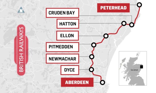
The proposed route the new rail line would follow from Aberdeen to Peterhead.
Plans to revive forgotten railway stations around the north-east won’t just benefit rural residents, but could actually help save the planet.
Earlier this year Campaign For North-East Rail (CNER) set out plans to bring modern infrastructure to the “forgotten” corners of Aberdeenshire, reopening rail links to Peterhead, Fraserburgh and Banchory.
Primarily the proposals look to offer a lifeline for what they call “isolated communities”. The Buchan towns of Peterhead and Fraserburgh have the dubious honour of being further from the British rail network than any other town in the UK.
But a new environmental report suggests that the impact of reintroducing rail links to the region wouldn’t just benefit residents and local businesses, but would also significantly contribute to saving the planet.
Step One: How to save 80 million miles of CO2
According to the group’s calculations, the railway could save at least 32,000 tonnes of carbon annually.
That is the equivalent of more than 80 million miles in an average car, or the carbon footprint of operating a UK university for six months.
“Rail is a drastically more efficient way of moving heavy goods and, of course, passengers,” said Wyndham Williams, an engineer and one of the minds behind the CNER report.
“The main reason for that is from an engineering perspective. Frictional losses are so much lower – rails on a track are much more efficient than rubber tyres on a road – and the other main reason is that you can also stack up freight trains so they have 50 containers on them.
Which means one locomotive is hauling the equivalent of 50 trucks with 50 diesel engines.”
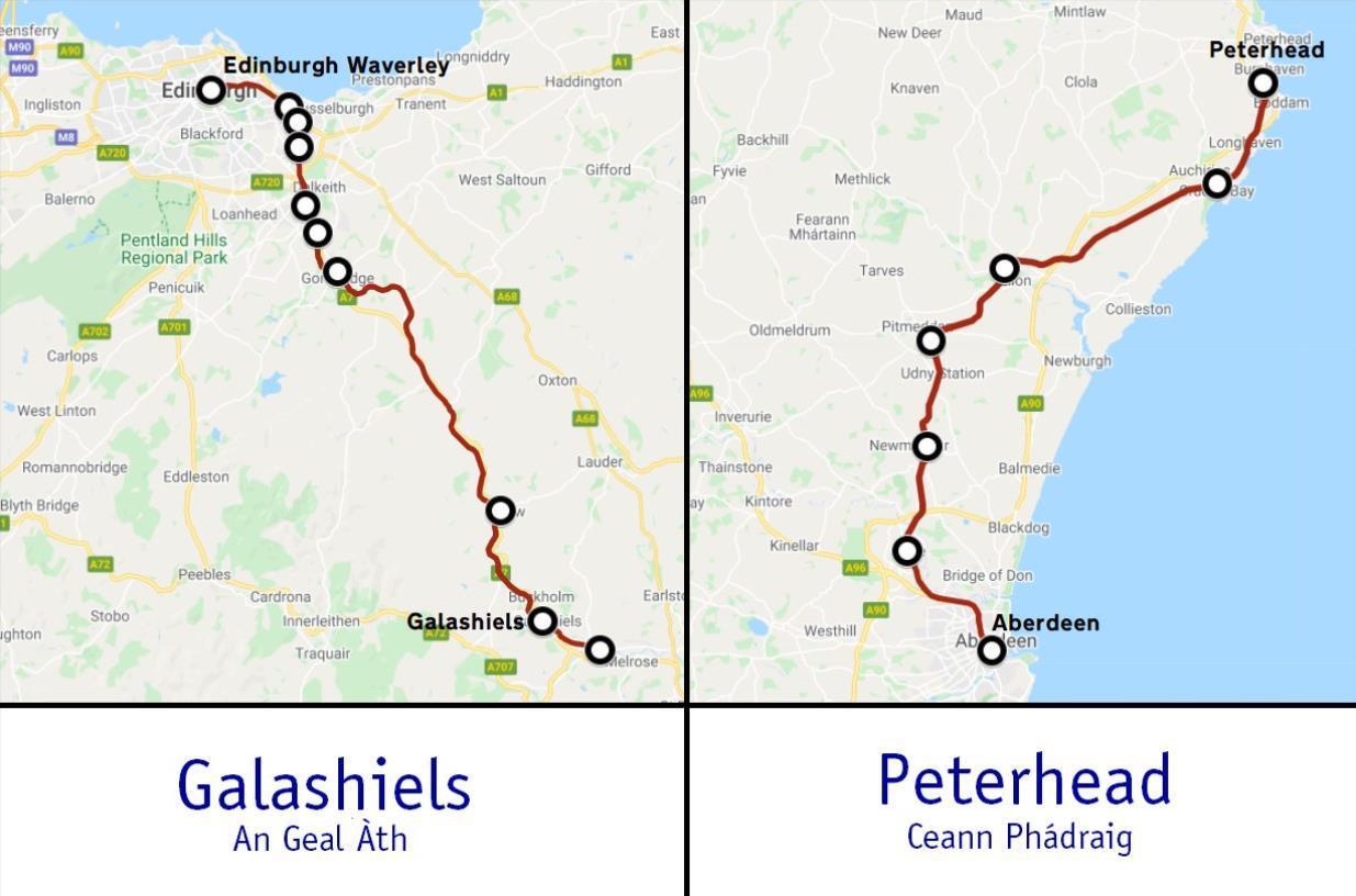
Step Two: How did the Borders Railway do it?
Sitting down to crunch the numbers, the group applied strict parameters to their workings.
Together they analysed everything from vehicle statistics, regional tourism and oil and gas freight, to Brewdog beer shipments, fish tonnages and HMP & YOI Grampian visitor numbers.
These numbers were carefully measured and cross-checked before the group compared their findings to the Borders railway.
The Borders Railway has a lot of similarities to the proposed Buchan route.
Opened in 2015, the Borders to Edinburgh railway line reconnected Galashiels and other local communities with Scotland’s capital by rail for the first time in 45 years.
With virtually the same length of track, the same number of stations and a similar population, the two railways have a lot in common.
Comparing the Borders and Buchan railways
Railway Length Stations Largest town Population Pre existing railway Cost
Borders Railway 35.3 miles 10 Galashiels 14,632 4.19 miles £426.28 million
……………………… (56.8km) (6.75 km) (CAD ($740.3)
Buchan Railway 35.1 miles 7 Peterhead 19,270 5.95 miles £401.79 million
………………………. (56.50 km) (9.57 km) (CAD $697.8)
“It’s been a blessing really that the Borders railway has been done,” said Mr Williams. “We don’t have to make guesses, we’ve actually got data, we’ve got passenger numbers, we’ve got costs.
“Peterhead and Galashiels are comparably sized places which are very similar in distance to the nearest big city, so we can lift this data and apply it to the north-east economy to make very reasonable assessments.”
Step Three: Rail freight is key
One of these assessments is that 450,000 trips will be shifted from private car to rail each year, but it’s not just passengers who will be reducing their CO2 contribution by taking the train.
Significant expansion of rail freight is a key ambition of the Scottish Government, precisely because of how much carbon can be saved shifting goods in this way.
Not only is less carbon released, but Mr Williams and others working on the campaign believe that long haul freight will be moved faster and more reliably on the proposed Buchan line, removing thousands of lorries from congested roads.
“Plus the route will be fully electrified from day one,” he said, referencing one of the Scottish Government’s other ongoing programmes, a zero-carbon railway by 2035.
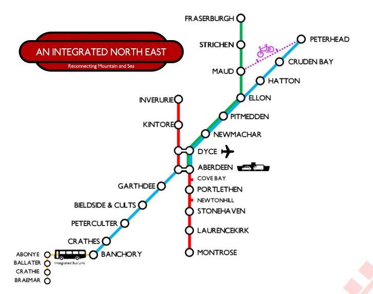
The campaign’s railway map of its proposals, which include an integrated bus link between Banchory and Braemar.
“This means it will use 100% renewable fuel and no carbon would be generated from the journey at all, whether its freight or passenger.”
If they’re right, the numbers make for a compelling environmental case in favour of the proposed railway.
The investment and upheaval might seem huge from where we are standing now at the starting line but without big long-term projects like this which challenge the status quo, it’s difficult to see how Scotland will achieve its green targets.
“I was personally quite surprised by the numbers,” said Mr Williams. “I have never looked at anything like this before but the numbers are very compelling. There is a huge contribution to be made here.”
Regional rail passenger services offers a quality alternative to the car.
An interesting passage from Steve Munro’s critique of Neptis, which I was reading to gain some insight into the organization, in response to Mr. Burgess’s comment.
Towards the end of this lengthy report, this paragraph stood out.
The whole point of Transit City was to provide improved local, trunk services and to remain on the surface wherever possible to minimize capital costs while avoiding the sterilization of between-station areas with the wide spacing typically found on subway projects.
Let me restate the point of concern.
………. (transit is) to remain on the surface wherever possible to minimize capital costs while avoiding the sterilization of between-station areas with the wide spacing typically found on subway projects.
So now the truth come out, the Broadway subway will sterilize surface business’s along Broadway, between the subway stations.
This contrary to what TransLink and the Mayor of Vancouver is saying! This contrary to hosannas being sung about the subway by the Daily hive and the rest of the mainstream media.
The Broadway subway will harm surface businesses and the City of Vancouver and TransLink are cowards for not telling merchants the truth, that the Broadway subway will sterilize Broadway!
Well, things have changed in a year and a half. The Trudeau Liberals have promised that they will fund 40% of the Expo Line Extension to Langley, but premier Horgan and TransLink have not, as yet, anted up the money to pay for their portion.
With a cost, now around $3.95 billion, the 16 km extension of the Expo Line to Langley, remains about $800 million unfunded and that was with earlier cost estimates!
But Trudeau’s announcement made a fine photo-op for the now soon to be called federal election.
As the real cost for the 16 km extension of the Expo line to Langley, now needing a serious updating, combined with the wildfire fiasco and the ongoing Covid waves, again I ask:
Where is this funding coming from?
The chap who uses the avatar Haveacow is a transit and transportation expert and it is a must, reading his comments; I certainly do!
I have been in this game for almost 35 years and the song sung by the SkyTrain lobby never changes.
Those defending light metro in Metro Vancouver never deal with costs.
Current politicians defend the Broadway subway because they say all infrastructure investment is good, while ignoring the costs. Using Toronto Transit Commissions numbers, the annual cost to operate and maintain a 5.8 km subway is around $40 million annually. That is $40 million added to the current operating costs of the light metro system.
Where is the money coming from?
From fares?
I doubt it as the subway is right on the main transit route to UBC where the deep discounted U-Pass is used by students and anyone else working at UBC.
So where is this funding coming from?
Higher taxes, higher fares and a diminished bus service south of the Fraser.
But the local taxpayer is on or near his/hers breaking point paying ever higher taxes, with many older pensioners fleeing the TransLink tax zone, creating even more congestion throughout the Fraser Valley. Zwei is soon to do this as well.
So it is important to consider tempering TransLink’s claims and start worrying about costs.
We build with a light metro system that costs up to ten times more to install than LRT (TTC ART Study)
We operate a light metro system that costs more to operate and maintain than LRT
We operate a light metro system that desperately needs refurbishing, yet TransLink remains mute on the subject.
Cost is a dirty word in TransLink’s lexicon.
Graph prepared by Metrolinx to inform the debate on choice of modes
In its entirety.
@Fredinno,
The figure is 15,000 not 1500 passengers per hour per direction for the maximum theoretical capacity of the Skytran network. .
@Rico,
The actual figure given to C.U.T.A. by Translink for 2018 is 14200. I have no doubt that it can vary quite widely day to day (most systems do have a wide variation in daily traffic) up to14800 or even higher, however your the power system and existing track turnouts (switches) and track configuration make operations consistently above that level problematic. New higher speed turnouts need to be installed because the ones used now require the trains to slow down dramatically. Higher speed turnouts are longer with frogs (turnout points) that are at a longer angle, which means all your track geometry has to change as well as having to relocate signalling and power equipment.
Yes, you can even operate for short periods above 15,000 p/h/d but it is not recommended. Any changes to that will also require new signaling and communication equipment and signal processors. The current communication equipment can’t react fast enough if you are operating at or beyond its limit. Legally, 1 train every 109 seconds is the operational limit.. This limit is set by Transport Canada and the Transportation Safety Agency. If you want to lower the operating frequency a new proving test and schedule has to be approved. This can take 2 years as long as Translink has the improvements in place so that the testing can begin. One major problem, the existing electrical power system for the entire network is at its limits. More trains increases the electrical resistance on the system that ,lowers the electrical current level, its the electrical current or flow that actually moves the trains.
Most of the cabling that attaches all this track and signaling infrastructure to the power system and the operating system is old and also in desperate need of replacement. The fires you have along the tracks are because animals and birds are building nests on top of or traveling along the cables. Their claws, talons and beaks have cut into the now aging and probably non-pliable overly rigid cable sheaths and are causing shorts. Many of the cable connectors and brackets are also in need replacement.
Can you increase the capacity of each train by increasing the size of the trains (which is exactly what they are doing) yes but again, there are conditions to this. The more you go over the limit of 15,000 p/h/d you severely tax the Citiflo 650 operating system. Bombardier is now no longer updating the Citiflo 650 and Bombardier is switching to a new automation operating system, which means knowing Bombardier, all new equipment will need to be purchased. Bigger trains increase the electrical resistance on the power system, which lowers the current available. Drop the current too low and everything stops. Can you fix this sure, but that requires more new electrical infrastructure, that costs big money!
Much of the existing infrastructure on the core part of the Expo Line is 33-36 years old depending on the construction date, remember it opened in 1986, much of the bridges and concrete could be at least 36 or even 37 years old now. Concrete ages geometrically, the longer you put off refurnishing said concrete, the more the costs grow above just inflationary pressure. I saw much concrete patch work on the underside of the viaducts during my last visit but no rebuilt new concrete sections. The concrete base plate that the track actually sits on needs work and isn’t getting it..
@Rico and @Fredinno,
Passenger flows of 25,700 are possible but will require 5 car trains, an updated and new automation operating system, major overhauls of electrical and signaling infrastructure. Track work will also have to be done, base plate and viaducts will require refurbishment to the steel reinforcement and concrete. This sounds simple but it is very expensive and time consuming. Very, very time consuming on an operating line. The existing infrastructure just can’t do the passenger flows you want . The vast majority of this work hasn’t even been budgeted yet by Translink.
$860 million in brand new signaling infrastructure as well as some tunnel reinforcement and track upgrades have been happening on Subway Line #1 in Toronto. This is the 66 year old, Yonge-University-Spadina-York subway line which is the busiest in the country. The TTC has been shutting down sections of the line on weekends for 7 and half years now to do all the work required. This was the preferred choice compared to shutting the whole line down for 1.5-2 years. It appears they will still be doing work on it well into 2020.After that, they have to do line #2, the Bloor-Danforth Subway Line.
Lastly, more new and larger trains mean a new yard for. You guys are out of yard space. A new maintenance and storage yard for Skytrains was planned in the follow on extension of the Expo Line to Langley. However, a spy of mine just told me that, due to ever increasing land costs in the Lower Mainland of B.C., the yard may have to be built as part of an interim extension because the cost of going all the way to Langley and building a new maintenance and storage yard at the same time is not affordable, unless senior levels of government pay for the whole line. Translation, Translink can’t afford its 33% and in this case, even 20% of the expected cost of the line is to high to get to Langley as well as build any other extensions at the same time. Like the extension of the Millennium Line to UBC from Arbutus.
Will this be a game changer for light rail in Canada?
For over thirty years, lawned rights-of-way have been the norm on European tramways and light rail operations; even the Deutsche Bahn (German Federal Railway) investigated lawend rights-of-ways for the main line railways.
Today, the lawned R-o-W’s are a fixture of the modern tram.
The new tramway in Luxembourg has extensive lawned rights-of-ways
Not so in Canada, where local bureaucrats, ever so scared of change, would not allow lawned R-o-W’s with excuses such as they were a fire hazard or emergency vehicles can’t us them (well if properly designed, they can).
Years ago in the early 90’s, at a City of Vancouver open house for concepts for the Arbutus Corridor, Zwei had a display of modern LRT, with every picture showing the then revolutionary lawned R-o-W, which contrasted quite well BC Transit photos of start gravel and asphalt R-o-W’s.
A gentleman approached me and said” I live on the Arbutus and if they did that (install a lawned R-o-W), I could not mount much of an objection“.
The chap from BC transit, overhearing the comment, quickly added; “But here in BC, they would be a safety and fire hazard”
Zwei thinks the real issue was that modern light rail, operating on a “Green” lawned R-o-W would be a positive ‘sell’ to the public and with light rail having operating characteristics that surpass light metro, would forever relegate the much more expensive and politically acceptable light metro to that dead branch of transit evolution.
A Paris tram, operating on a lawned R-o-W.
Toronto thus becomes the first Canadian city to have lawned-R-o-W’s, after years of kicking and screaming entrenched anti Green cabal. Toronto is laying “Green” track and joining the modern world of Light Rail Transit.
The first of three green track areas along Eglinton Crosstown LRT’s at-grade section is being installed at Warden Avenue’s Golden Mile stop.
Construction of the Eglinton Crosstown light rail transit (LRT) project continues to progress, and one of its latest milestones may have you seeing green.
Portions of the at-grade section, east of Brentcliffe Road, will feature green tracks to help integrate the new transit line with Eglinton Avenue’s many parks and green spaces.
The ’green’ will be made up of grass and additional foliage planted down the middle of the LRV route.
A mock-up of the green tracks, totalling 16 metres in length and 92 square metres in area, has been installed at the Golden Mile stop east of Warden Avenue.
The installation of each section of green track takes three months after the final design is approved. Each section will include irrigation chambers, water supply, and an energy supply to power the irrigation system.
The partially installed green track mock-up at Warden Avenue’s Golden Mile stop looking east. (Metrolinx photo)The partially installed green track mock-up at Warden Avenue’s Golden Mile stop looking west. (Metrolinx photos)
Not only do the green tracks look good, but they serve a purpose.
Swapping out concrete for grass can help keep temperatures down in the heat of summer. Grass and other vegetation can also act as a sound dampener, absorb rain to reduce run-off, and even minimize the spread of dust.
It’s all part of Metrolinx’s goal to provide environmentally sustainable light rail transit service across Toronto.
Story by Katherine Abraham, Metrolinx Community Relations Specialist


Trans-Canada Highway, seen here at the 216th Street interchange in Langley. (Langley Advance Times file)


_par_Cramos")


Recent Comments